

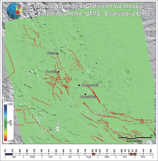
SENTINEL 1A/1B - Sequenza sismica Italia centrale 2016 (aGGIORNAMENTO DEL 09/01/2017)

L'animazione mostra la deformazione del suolo cumulata, ottenuta processando i dati SAR acquisiti in geometria ascendente dai satelliti Sentinel 1A/1B (https://sentinel.esa.int/web/sentinel/home) sull'Italia centrale durante gli ultimi 8 mesi. Durante questo periodo, l'area è stata caratterizzata dalla sequenza sismica iniziata il 24 Agosto con i "Terremoti di Amatrice" di Mw 5.4 e Mw 5.6, seguiti il 26 Ottobre dai " Terremoti di Visso" di Mw 5.9 e Mw 5.4, e dal "Terremoto di Norcia" di Mw 6.5 avvenuto il 30 Ottobre.
Il processamento SAR è stato esuguito usando l'approccio SBAS (Small BASeline). La serie storica non mostra evidenze di deformazioni del suolo fino ai "Terremoti di Amatrice", quando è stato registrato uno spostamento di circa 20 cm lungo la linea di vista del sensore (LOS - Line Of Sight); i successivi "Terremoti di Visso" hanno prodotto un associato campo di deformazione a N-W rispetto al precedente; dopo soli 4 giorni il "Terremoto di Norcia" Mw 6.5 ha prodotto il maggiore campo di deformazione, riempiendo il gap tra i precedenti.
SENTINEL 1A/1B - 2016 central italy seismic sequence (UPDATE 09/01/2017)
The animated gif shows the cumulated ground deformation recorded by processing the SAR data acquired in ascending orbit by Sentinel 1A/1B satellites (https://sentinel.esa.int/web/sentinel/home) on central Italy during the last 8 months. During this time interval, this area was characterized by the seismic sequence started with the August 24th Mw 5.4 and Mw 6 “Amatrice earthquakes”, followed by October 26th Mw 5.9 and Mw 5.4 “Visso earthquakes” and October 30th Mw 6.5 “Norcia earthquake”, among thousands of minor seismic events .
The SAR processing was performed using the SBAS (Small BASeline) approach. The time series shows that no evident ground deformation was visible until the Amatrice earthquakes when a displacements of about 20 cm along the LOS (Line Of Sight) has been recorded; the following Visso earthquakes, produced a new displacement field northwards; after 4 days the Mw 6.5 Norcia earthquake produced a biggest ground displacement filling the gap between the previous ones.
DOWNLOAD THE COMPLETE ANIMATION AT FULL RESOLUTION (5.575 KB)